


As the Chinese Communist Party (CCP) continues to modernize the People’s Liberation Army (PLA), Navy (PLAN), Air Force (PLAAF), and Rocket Force (PLARF) in order to meet its strategic goals in the South China Sea, the United States Intelligence Community must contend with an increasingly sophisticated challenge to collection efforts in that region. Lawmakers and military decision makers enjoy a wide variety of options when conducting Intelligence, Surveillance, and Reconnaissance (ISR) against near-peer adversaries such as the Russian Federation and off-axis adversaries such as Iran, chiefly due to the access and placement of operating bases of allies.
However, the Spratley and Paracel Islands present a conundrum to U.S. military planners in that airborne ISR collection missions must be flown at extended ranges from American or allied bases, where these high value assets are extremely conspicuous and vulnerable. The advent of beyond-visual-range (BVR) air-to-air missiles in the PLAAF, integration of long range surface-to-air missiles (SAMs) on the burgeoning fleets of the PLAN, and the deployment of PLARF strategic long range SAMs on these islands is eroding the relevancy of American airborne ISR assets and forcing Washington to rely on space based assets to accomplish those collection missions.
In 2019, the Defense Intelligence Agency published its China: Military Power Report which correctly outlines the CCP’s strategic goal of challenging the U.S. dominated global hegemony since the fall of the Soviet Union and cement the legitimacy of the Party’s rule to the Chinese middle class which has gained significant power in government. The primary lever of power the CCP hopes to leverage in order to accomplish this goal is through the military in which the historic precedent of defensive wars is dissolved by a modern and powerful military capable of projecting power beyond China’s borders. Beginning in the mid-1990’s this modernization has been working to counter the air dominance that the United States has enjoyed and put on world display during the 1991 Gulf War. The Paracel Islands, which the CCP seized from Vietnam in 1974 and the Spratley Islands, claimed and fortified throughout the mid 2000’s to present , has been the CCP’s main effort in solidifying dominance in the First Island Chain, which encompasses the South China Sea and Taiwan. The CCP also seeks to challenge the United States out to the Second Island Chain which encompasses the territorial waters of Japan, and finally disrupt U.S. operations in the Third Island Chain, which extends to Hawaii.
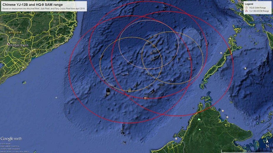
In order to monitor the movement and activities of an increasingly aggressive PLAN in these waters, the United States Navy (USN), specifically the 7th Fleet, has been strained to execute Freedom of Navigation Operations (FONOPS) with its 50-70 operational sub-surface and surface combatants against the nearly 200 surface combatants of the South and East Sea Fleets, not to mention the hundreds of Chinese Coast Guard and Maritime Militia vessels. Therefore, U.S. ISR assets are required to make extended flights from Guam and Japan in order to provide Signals Intelligence (SIGINT), Measurement and Signature Intelligence (MASINT), and Full Motion Video (FMV) coverage to this wide swath of ocean. These platforms include, but are not limited to the P-8 Poseidon, MQ-9 Reaper, and the E-8 JSTARS. However, these multi-million dollar platforms and their highly classified sensors, despite their impressive range, are faced with the daunting task of flying into the weapon engagement zones (WEZ) and the missile engagement zones (MEZ) of the PLA’s HQ-9, HQ-22 and Russian built S-400s which dot the Chinese coastline on the Taiwan
Strait and fortify the Chinse claimed islands in the South China Sea. The arming of PLAAF with advanced BVR air-to-air missiles such as the PL-15 on 5th generation fighters like the J-20 also provides China with the exquisite capability of destroying these platforms in an area dominated by Chinese firepower. This expansion of the PLA’s MEZ and the PLAAF’s WEZ, not to mention the highly capable SAMs onboard Chinese surface combatants mean that American airborne ISR and even Command and Control (C2) aircraft are at such incredible risk that they cannot be employed comfortably against Chinese targets that have been traditionally collected on. The risk is so significant that monitoring of the Spratley and Paracels is almost exclusively done by satellite imagery, where the PLARF is quickly developing anti-satellite (ASAT) weapons to counter that capability as well.
In order to counter the increasingly potent missile threat in the First Island Chain, lawmakers must consider three options: re-opening Subic Bay and Clark Air Base in the Philippines, trade manned ISR flights for a larger inventory of unmanned sensors, and increase the inventory of U.S. space based ISR satellites, assigned exclusively to the Chinese problem set. The USN base at Subic Bay and the USAF base at Clark Airfield were closed in 1992 after the U.S. and Filipino governments were unable to come to an agreement on the leasing cost for the bases. At the time, the negotiation gap was five hundred millions dollars. The benefit of re-opening would be a much more potent concentration of U.S. assets in close proximity to the South China Sea as opposed to Hawaii, Guam, or Japan. However, after nearly 30 years of Filipino control, the costs of re-occupying the base and negotiating a new lease would most likely be in the tens of billions. Although the two governments came to an agreement in 2016 to allow U.S. troops to deploy to five Filipino airbases, the resident status is not nearly enough. That deal would have to be greatly expanded. The second solution, transitioning manned ISR flights for unmanned would give the benefit of longer dwell times and less risk to American aviators in the contested airspace, but again would present a massive price tag to the American people, most likely in the tens of billions of dollars to achieve parity with manned collection assets. The third solution, launching at least another dozen MASINT, SIGINT, and GEOINT satellites to alleviate the absence of airborne ISR assets in the First Island Chain, would give the benefit of less risk to our manned aviators, but would also take years and billions of dollars for such exquisite sensors.